



Cayman compass
Le gouvernement des îles Caïmans a entamé l’examen des mesures nécessaires pour régler les questions de frontières maritimes restantes du territoire avec la Jamaïque et Cuba, tandis que les îles Caïmans continuent de renforcer leur capacité à comprendre, protéger et gérer la zone maritime qui les entoure.
Le représentant maritime outre-mer des îles Caïmans, Max Mifsud, a confirmé au Compass que des travaux sont en cours pour déterminer comment faire progresser le règlement des frontières, longtemps restées sans solution, dans le cadre du droit international.

« Dans le cadre d’une récente restructuration de l’administration maritime, le gouvernement a pris des mesures pour renforcer la coordination dans l’ensemble du secteur – non seulement pour soutenir la conformité au Code de mise en œuvre des instruments (III) de l’Organisation maritime internationale, mais aussi pour approfondir l’engagement avec les parties prenantes de manière plus coordonnée et stratégique, en vue de maximiser les opportunités offertes par l’économie bleue », a déclaré Mifsud.
« Dans le cadre de cet effort plus vaste, le gouvernement a examiné les questions relatives aux frontières maritimes. »
Il a ajouté : « Nous pouvons confirmer que des travaux sont actuellement en cours pour examiner les mesures appropriées à prendre afin que nos zones maritimes restantes soient correctement délimitées conformément au droit international. »
Cette évolution intervient alors que les îles Caïmans ont considérablement renforcé leurs capacités maritimes dans d’autres domaines, notamment la surveillance du domaine maritime, la recherche et le sauvetage, la protection de l’environnement, la lutte contre la pollution et la connaissance scientifique de leurs eaux territoriales.
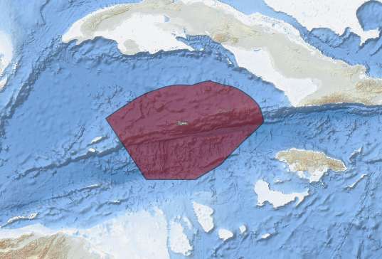
En décembre 2025, les îles Caïmans ont achevé une ambitieuse étude autonomeportant sur environ 90 000 kilomètres carrés de fonds marins au sein de leur zone économique exclusive.
L’étude a fourni des informations à haute résolution couvrant des eaux allant d’environ 20 mètres à 7 000 mètres de profondeur, y compris d’importantes zones de pêche hauturière telles que 60 Mile Bank, Lawfords Bank, Pickle Bank et 12 Mile Bank.
Cayman has also expanded its Coast Guard, while government has announced plans to improve maritime domain awareness through new radar capability.
At the same time, the Department of Environment and UK Blue Belt Programme are increasing research into Cayman’s comparatively little-studied offshore environment, including fisheries, deep-sea habitats, pollution and ocean acidification.
But one fundamental element of Cayman’s maritime domain remains unfinished; precisely defining its boundaries with two of its closest neighbours.
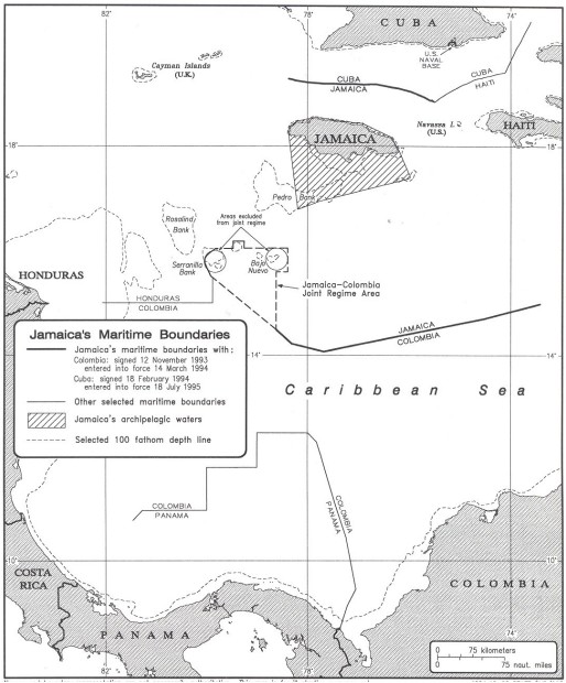
Cayman’s maritime boundary with Honduras was settled by treaty in 2001, but the boundaries with Jamaica and Cuba remain unresolved.
The issue dates back decades. In 1977, Governor Thomas Russell issued a proclamation establishing a Cayman Islands Fisheries Zone based on equidistance between Cayman and neighbouring Honduras, Jamaica and Cuba.
That established fisheries jurisdiction over a large area but did not constitute final maritime boundary agreements with all three neighbours.
Under the United Nations Convention on the Law of the Sea, maritime boundaries between states with opposite or adjacent coasts are to be established through agreement under international law with the objective of achieving an equitable solution.
Settling those boundaries ultimately determines where neighbouring jurisdictions’ respective rights apply over resources including fisheries and the seabed.
Previous Cayman government statements indicated there was interest from both Jamaica and Cuba in restarting discussions.
Mifsud’s latest response indicates government is now reviewing how to move the process forward, although no timetable for formal negotiations has been announced.
“We recognise that progress on this matter will require constructive engagement and negotiation with neighbouring states, and we look forward to resuming those discussions in due course,” he said.
For Cayman, completing those negotiations would add a final legal component to an increasingly sophisticated understanding and management of the maritime territory surrounding the Islands, and defining not only what lies beneath Cayman’s waters, but precisely where those waters